 |
| Back to Contents |
| |
|
|
Introduction |
1.1 |
This document, which was adopted by the Council on 17 December 2009, sets out details of allocations for housing, retail and open space. It is part of the Council’s Local Development Framework. |
1.2 |
The allocations in this document relate to specific policies in the Core Strategy and Policies DPD and assist in implementing these policies: |
|
- Allocations A1-A5 and A7-A9 are for housing developments1. These assist in delivering Strategic Policy SP2 which seeks to ensure provision is made for sufficient housing to meet the Regional Spatial Strategy for the South East requirement for Spelthorne. It also supports detailed Policy HO1(a) which identifies bringing forward specific sites through Allocations DPDs as a measure to ensure provision for housing is made.
- Allocation A10 is for extensions to the Elmsleigh Shopping Centre in Staines. It assists in delivering Strategic Policy SP4 on town centres and retail development by ensuring town centres remain the focus of new retail development and specifically the improvement of Staines. It supports detailed Policy TC1 which identifies the scope and role of extensions to the Elmsleigh Centre in providing additional retail floorspace. The allocation also includes a residential element on the upper floors which supports Strategic Policy SP2 and detailed Policy HO1(a) in identifying specific housing allocations.
- Allocation A11 is for an area of public open space west of Edward Way, Ashford. It assists in delivering Strategic Policy SP5 on meeting community needs and detailed Policy CO1(a) in the provision of new community facilities.
|
| |
1.3 |
The allocations have been subject to a sustainability appraisal, including a sequential approach to development in the flood plain in conformity with Planning Policy Statement 25, to ensure that they are consistent with the principles of sustainable development. The Sustainability Appraisal Report is available separately. |
1.4 |
Additional Allocations DPDs may be brought forward to identify further specific housing allocations for the plan period of the Core Strategy and Policies DPD. |
1.5 |
By virtue of the Planning and Compulsory Purchase Act 2004 all the policies and proposals contained in the adopted Borough Local Plan 2001 expired on 27 September 2007, with the exception of those which were ‘saved’ by a Direction of the Secretary of State dated 21 September 2007. All of the five ‘saved’ proposals P7, P8, P11, P12 and P17 were saved until the adoption of this DPD. |
|
|
|
Status of Allocations |
2.1 |
The Council will support the development of the allocation sites for uses set out in this DPD. |
2.2 |
This means that in principle it will support planning applications to carry out the development proposed and be opposed to planning applications for development that conflicts with the allocation. Planning applications to carry out development for uses set out in this document may still be refused if the details of the scheme are not acceptable. |
2.3 |
The existence of an allocation does not mean that the Council intends to purchase the site. In most cases it is envisaged that the development will be brought forward and carried out by the private sector and not by the Council. |
|
|
3 |
Information on Allocations |
3.1 |
Allocations are grouped under the following categories: |
| |
- Housing developments (Allocations A1-A5 and A7-A9)
- Town Centre developments, including mixed use schemes (Allocation A10)
- Open Space (Allocation A11)
|
3.2 |
For each allocation the following information is provided: |
| |
- Site description
- Allocation
- Timescale of development - approximately when, during the plan period, it is envisaged that the development will take place.
- Justification for allocation
- Development Criteria - any particular requirements relevant to the development of the site.
- Relevant Policies - from the Core Strategy and Policies DPD. This identifies which specific policies the allocation relates to and therefore assists in delivering.
|
3.3 |
All development proposals will need to comply with the relevant detailed policies in the Core Strategy and Policies DPD. The following will be particularly relevant in the case of housing allocations: |
| |
- Policy LO1: Flooding
- Policy HO3: Affordable Housing
- Policy HO4: Housing Size and Type
- Policy HO5: Density of Housing Development
- Policy EN1: Design of New Development
- Policy CC1: Renewable Energy, Energy Conservation and Sustainable Construction
- Policy EN9: The setting of the River Thames and its tributaries.
|
3.4 |
Where information on flood risk is included in the development criteria for particular allocations it is based on the flood maps referred to in paragraph 5.11 of the Core Strategy and Policies DPD and as set out on the Proposals Map. However, when considering development proposals on any of the allocation sites the Council will always have regard to the latest flood maps published by the Environment Agency. |
|
|
4. |
Delivery of Housing Allocations |
4.1 |
The housing allocations in this DPD were identified through the Housing Capacity Study of April 2005 and the Housing Land Availability Assessment January 2007 (base date April 2006). Most are existing employment sites which are considered to be more appropriate for residential use. The loss of these employment sites in terms of employment capacity will be compensated by employment development, much of which has already been approved. Additional employment needs through the plan period will be met through intensification of the identified Employment Areas safeguarded for employment use in the Core Strategy and Policies DPD. |
4.2 |
The owners/occupiers and neighbours of the sites were consulted in the preparation of this DPD. The owners generally agree to the principle of residential development. The timescales when sites are indicated to come forward for development have had regard to the owners’ stated intentions. |
4.3 |
The Regional Spatial Strategy for the South East requires Spelthorne to provide 3320 new dwellings in the period 2006-2026, which equates to 166 dwellings per annum. The Core Strategy and Policies DPD sets out how this requirement will be met. The housing allocations set out in this DPD are large sites of 0.4ha or larger which are identified to give certainty to the delivery of Spelthorne’s overall housing requirement. However, only an approximate number of dwellings is set out for each allocation site on the basis that the precise form of development, and therefore the detailed number of units, is best determined at the detailed planning stage, taking into account all relevant factors. |
4.4 |
The sites are included in the housing trajectory which is prepared in accordance with the requirements of PPS3 and updated annually. The housing trajectory is reproduced in the Annual Monitoring Report (AMR) and shows how Spelthorne’s housing supply will be delivered over the plan period to 2026. |
|
|
5. |
Monitoring and Implementation |
5.1 |
The Council will monitor progress towards implementing the allocations in this DPD as part of its overall monitoring of the Local Development Framework. The information monitored will be published each year in the Annual Monitoring Report. Where there is evidence that allocations may be delayed the Council will, if necessary, seek to overcome any obstacles to implementation. In accordance with Policy HO2 in the Core Strategy and Policies DPD it may consider using compulsory purchase powers to bring forward sites but only as a last resort after options for negotiated agreement have been exhausted. |
5.2 |
The monitoring framework sets targets and indicators and identifies the delivery agencies for the allocations in this DPD. The progress with the housing allocations will be monitored through the housing trajectory. A more detailed monitoring framework for the Core Strategy and Policies DPD can be found in Chapter 12 of that document. |
|
|
|
Table 1 Monitoring Framework |
|
Allocation Ref |
Target |
Indicator |
Main Delivery Agency |
A1-A5 and A7-A9
(A6 deleted –see footnote on page 1) |
To deliver the allocations within the timescale indicated |
COI
H1: Plan period and housing targets
H2 (a): Net additional dwellings – in previous years
H2 (b): Net additional dwellings - for the reporting year
H2 (c): Net additional dwellings – in future years
H2 (d): Managed delivery target |
Private Developers, RSLs, The Borough Council |
A10 |
To deliver housing and retail development within the timescale indicated |
COI
H1: Plan period and housing targets
H2 (a): Net additional dwellings – in previous years
H2 (b): Net additional dwellings - for the reporting year
H2 (c): Net additional dwellings – in future years
H2 (d): Managed delivery target
COI BD4 – Total amount of floorspace for ‘town centre uses’
Community facilities granted or lost (local output indicator) |
Private Developers, The Borough Council |
A11 |
To deliver the site within the timescale indicated |
Date of provision of the site |
The Borough Council |
|
|
|
6. |
List of Allocations |
|
|
|
Housing Allocations |
|
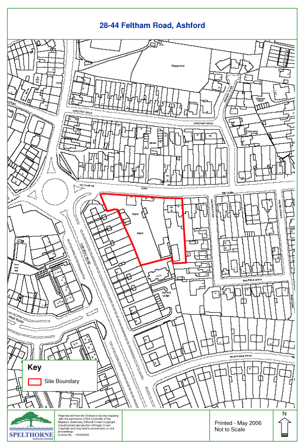
Allocation A1: 28-44 Feltham Road, Ashford (P/001/H) |
|
|
|
Site Description |
6.1 |
This site of 0.47ha is currently occupied by workshops and yards and is bounded predominantly by housing. Access to the site is through a mainly residential area. |
|
|
|
Allocation |
6.2 |
The site is proposed for residential development of approximately 23 dwellings. |
|
|
|
Timescale of development: post 2024 |
6.3 |
The site is in more than one ownership. The biggest landowner has no objection to the allocation, while the smaller landowner has no plans to release the site in the near future. The timescale allows flexibility in the timing of the development to help existing businesses to relocate and also accommodates the views of the existing landowners. |
|
|
|
Justification for allocation |
6.4 |
This site in a residential area and not considered to be a well-located commercial site. |
6.5 |
Residential development would enable the impact of commercial activity on the surrounding residential area to be reduced and make a contribution to meeting housing needs. |
|
|
|
Development Criteria |
6.6 |
Development requires relocation of existing commercial uses. |
6.7 |
The three existing residential properties on site can be retained as part of any development proposal. |
6.8 |
Thames Water require surface water flows to be attenuated to ensure no increase in peak discharge from the site. |
|
|
|
Relevant Policies |
6.9 |
The allocation supports implementation of Strategic Policy SP2 and Policy HO1(a) in the Core Strategy and Policies DPD. |
6.10 |
Planning applications for the allocated use will need to take particular account, amongst other policies, of relevant policies listed in paragraph 3.3 of this document. |
|
 |
|
|
|
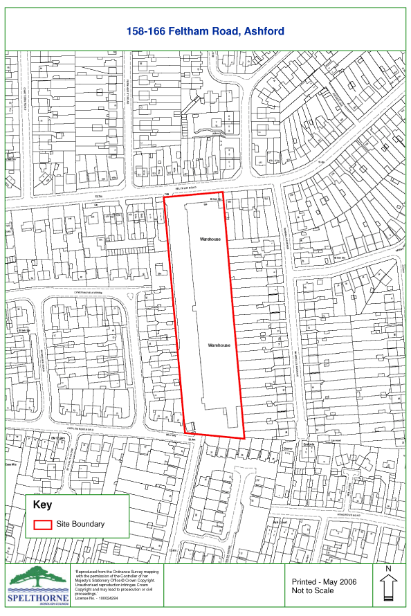
Allocation A2: 158-166 Feltham Road, Ashford (P/002/H) |
|
|
|
Site Description |
6.11 |
This long narrow site of 1.3ha is currently in warehousing use. There are quite substantial buildings on the site at present and it is bounded on three sides by residential properties. Access is through a primarily residential area. |
|
|
|
Allocation |
6.12 |
A housing density of approximately 50dph is proposed and it is considered that the site could be developed for a mixture of approximately 60 flats and houses. |
|
|
|
Timescale of development: 2014-2019 |
6.13 |
The landowner supports the allocation. |
|
|
|
Justification for allocation |
6.14 |
It is not considered to be a well-located commercial site. A former commercial site to the south, of similar size, was redeveloped in the 1990s for housing and it is considered that this site would also be suitable for residential. |
|
|
|
Development Criteria |
6.15 |
There is a shortage of public open space in the vicinity of the site and therefore there is a need to provide open space in accordance with Policy CO3. |
6.16 |
Neighbours have raised concerns about security and privacy. The design of the scheme will need to safeguard the privacy of adjoining properties. |
6.17 |
Thames Water requires surface water flows to be attenuated to ensure no increase in peak discharge from the site. |
|
|
|
Relevant Policies |
6.18 |
The allocation supports implementation of Strategic Policy SP2 and Policy HO1(a) in the Core Strategy and Policies DPD. |
6.19 |
Planning applications for the allocated use will need to take particular account, amongst other policies, of relevant policies listed in paragraph 3.3 of this document. |
|
 |
|
|
|
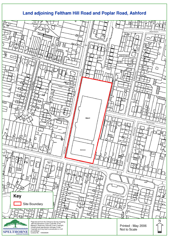
Allocation A3: Land Adjoining Feltham Hill Road and Poplar Road, Ashford (P/011/H) |
|
|
|
Site Description |
6.20 |
This site of 1.47ha is in warehousing use but is almost entirely vacant. It is bounded on three sides by residential and access is through a primarily residential area. There are some existing flats nearby fronting Feltham Hill Road and there are quite substantial buildings on the site at present. |
|
|
|
Allocation |
6.21 |
It is proposed that the site be developed for a mixture of approximately 70 flats and houses at a density of approximately 50 dwellings per hectare. |
|
|
|
Timescale of development: 2009-2019 |
6.22 |
The landowner supports the implementation of the allocation in the next ten years. |
|
|
|
Justification for allocation |
6.23 |
It is not considered to be a well-located commercial site. A former commercial site to the north, of similar size and orientation, was redeveloped in the 1990s for housing and it is considered that this site would also be suitable for residential. |
|
|
|
Development Criteria |
6.24 |
There is a shortage of public open space in the vicinity of the site and therefore the need to provide 0.1ha of public open space is also proposed in accordance with Policy CO3. |
6.25 |
In addition to the requirement to provide sustainable drainage systems (SUDS) an assessment of the local sewer network would need to be carried out in conjunction with Thames Water to ensure that smaller diameter sewers are not compromised. Multiple connections may be needed and a direct connection to a nearby large diameter sewer. There are public sewers crossing the site and any building within 3 metres of them would require approval from Thames Water. |
6.26 |
There is scope to develop this site in phases provided each element contributes to an appropriate comprehensive approach including the provision of adequate open space. |
|
|
|
Relevant Policies |
6.27 |
The allocation supports implementation of Strategic Policy SP2 and Policy HO1(a) in the Core Strategy and Policies DPD. |
6.28 |
Planning applications for the allocated use will need to take particular account, amongst other policies, of relevant policies listed in paragraph 3.3 of this document. |
|
 |
|
|
|
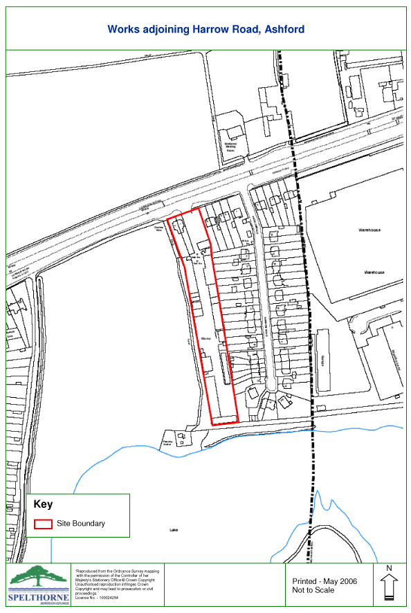
Allocation A4: Works Adjoining Harrow Road, Ashford (P/031/H) |
|
|
|
Site Description |
6.29 |
This long narrow site of 0.58ha has a short frontage to the A30 and is bounded by open land to the west and housing to the east. It is occupied by a range of small older-style workshops |
|
|
|
Allocation |
6.30 |
It is proposed that the site be developed for a residential development of approximately 36 dwellings at a density of approximately 60 dwellings per hectare. |
|
|
|
Timescale of development: 2019-2024 |
6.31 |
The landowners agree to the principle of residential development. |
|
|
|
Justification for allocation |
6.32 |
This is not a good location for commercial development due to the proximity of housing in Harrow Road. |
|
|
|
Development Criteria |
6.33 |
Design and layout will require particular care to ensure the privacy of adjoining properties is maintained and minimises any adverse impact on the adjoining Green Belt. |
6.34 |
Properties close to the A30 would need to be sited and designed to take account of road noise. |
6.35 |
Traffic movements on and off the A30 trunk road must have no greater impact than the current uses. |
6.36 |
The area is lacking in public open space but this would be rectified by the implementation of Allocation A11 on land to the west of Edward Way. |
6.37 |
Development proposals would require an assessment in conjunction with Thames Water as to whether local improvements to the sewerage network are required. Any improvements identified should be implemented prior to the occupation of the site. |
|
|
|
Relevant Policies |
6.38 |
The allocation supports implementation of Strategic Policy SP2 and Policy HO1(a) in the Core Strategy and Policies DPD. |
6.39 |
Planning applications for the allocated use will need to take particular account, amongst other policies, of relevant policies listed in paragraph 3.3 of this document. |
|
 |
|
|
|
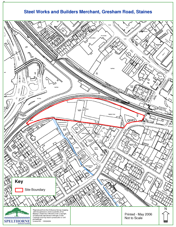
Allocation A5: Steel Works and Builders Merchants, Gresham Road, Staines (P/028/H) 2 |
|
|
|
Site Description |
6.40 |
This site of 1.37ha comprises a yard occupied by steel stockholders together with a builders’ merchant. Although adjacent to Staines station and close to the town centre it is separated from the town centre by the railway. |
|
|
|
Allocation |
6.41 |
The location of the site makes it suitable in principle for a high density residential scheme, although the proximity of the railway and the narrowness of the site at the eastern and western ends may impose some layout constraints. Allowing for these factors a development of 100 flats is proposed giving a density of just over 70 dwellings per hectare. Non-family housing is proposed. |
|
|
|
Timescale of development: post 2024 |
6.42 |
The two landowners, Network Rail and Jewson Ltd, have no objection to the allocation, although the site is unlikely to be available until towards the end of the plan period. |
|
|
|
Justification for allocation |
6.43 |
Access to the site is via residential roads and the current use requires the movement of large lorries through a generally residential area. The commercial use is visually prominent and obtrusive both from Gresham Road and from the town centre. Redevelopment for housing is considered beneficial in environmental terms |
|
|
|
Development Criteria |
6.44 |
Part of the site is within Flood Zone 2. A flood risk assessment will be required with any planning application. |
6.45 |
Development would need to include noise mitigation from the adjoining railway. |
6.46 |
Development proposals would require an assessment in conjunction with Thames Water whether local improvements to the sewerage network are required. Any improvements identified should be implemented prior to the occupation of the site. |
|
|
|
Relevant Policies |
6.47 |
The allocation supports implementation of Strategic Policy SP2 and Policy HO1(a) in the Core Strategy and Policies DPD. |
6.48 |
Planning applications for the allocated use will need to take particular account, amongst other policies, of relevant policies listed in paragraph 3.3 of this document. |
| |
 |
|
|
|
|
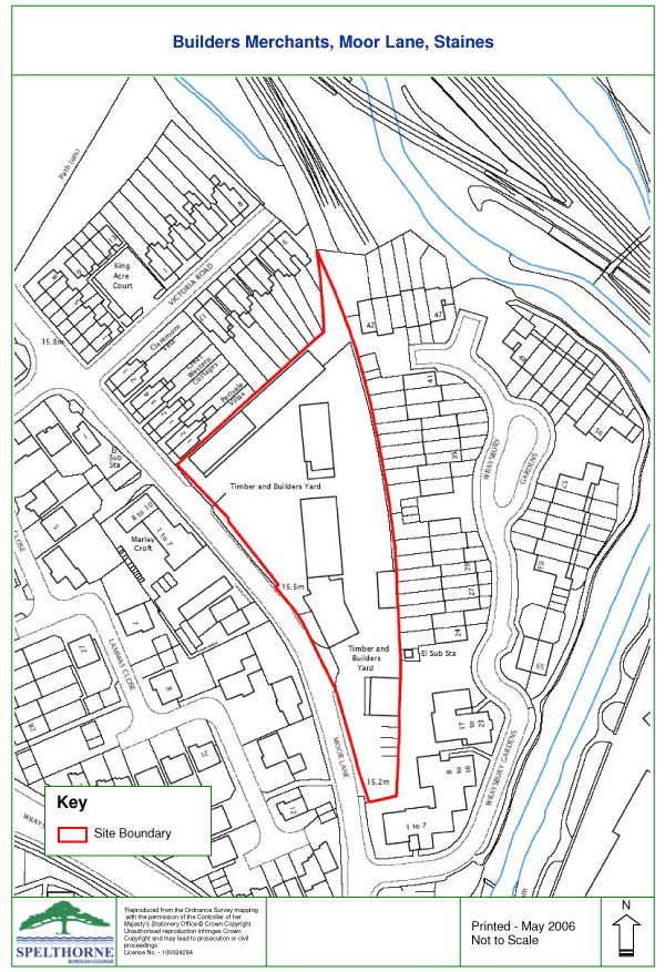
Allocation A7: Builders Merchant, Moor Lane, Staines (P/005/H) |
|
|
|
Site Description |
6.49 |
This site of 0.57ha is occupied by a builders merchant and timber yard and is surrounded by land in residential use. It forms the remaining part of a housing proposal in the Local Plan. |
|
|
|
Allocation |
6.50 |
The site is proposed for approximately 30 dwellings. The adjoining site has been developed with a mixture of housing and flats. The number of units assumes a mixture of flats and houses. |
|
|
|
Timescale of development: post 2024 |
6.51 |
The timescale takes account of the landowner response, which suggests the site is unlikely to become available in the short term. |
|
|
|
Justification for allocation |
6.52 |
The site is not well located for commercial use and is surrounded by residential development. |
|
|
|
Development Criteria |
6.53 |
The shape of the site and the proximity of adjoining housing means the design and layout will require particular care to ensure the privacy of adjoining properties is maintained. This limits the potential scale of development which is reflected in the number of dwellings proposed. |
6.54 |
The southern corner of the site is in Flood Zone 2. The acceptability of housing is subject to a satisfactory flood risk assessment of a specific scheme to confirm that it would raise no adverse flood issues. |
6.55 |
For reasons of pedestrian safety any proposal must make provision for a public footway for Moor Lane which forms the western boundary of the site. |
|
|
|
Relevant Policies |
6.56 |
The allocation supports implementation of Strategic Policy SP2 and Policy HO1(a) in the Core Strategy and Policies DPD. |
6.57 |
Planning applications for the allocated use will need to take particular account, amongst other policies, of relevant policies listed in paragraph 3.3 of this document. |
|
 |
|
|
|
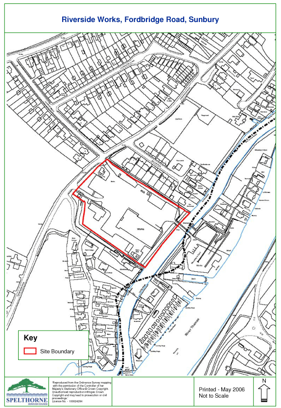
Allocation A8: Riverside Works, Fordbridge Road, Sunbury (P/026/H) |
|
|
|
Site Description |
6.58 |
This site of 1.57ha is owned by the Environment Agency. The site fronts the River Thames and provides access via a footbridge to Wheatley’s Eyot. The site is flanked by residential development on either side. |
|
|
|
Allocation |
6.59 |
The site lies towards the edge of Sunbury in an area of lower density housing. An on-site constraint is the need to retain access to the adjoining island of Wheatley’s Eyot. Development at a density close to the minimum of 35 dwellings per hectare, set out in Policy HO5 of the Core Strategy and Policies DPD, is assumed. Therefore the site is considered suitable for a residential development of approximately 50 dwellings. |
|
|
|
Timescale of development: 2009-14 |
6.60 |
The owners, the Environment Agency, are promoting the site for residential use. |
|
|
|
Justification for allocation |
6.61 |
Residential development would be more in keeping with the location and provides the opportunity to improve the setting of the River Thames. |
|
|
|
Development Criteria |
6.62 |
The design of any development proposal will have to be sensitive to the riverside location and make a positive contribution to the setting of the river. It also needs to avoid adverse impact on adjoining properties, which are physically at a lower level. Any proposal for demolition and construction work associated with the implementation of this allocation must be accompanied with an appropriate Method of Demolition and Construction Statement detailing how the works will be implemented to minimise any damage or nuisance to neighbouring properties. |
6.63 |
Any development would need to provide access to the adjoining island of Wheatley’s Eyot. |
6.64 |
The site is on raised ground and is within Flood Zone 2. A flood risk assessment undertaken for the Environment Agency has shown that residential development is acceptable. However any development proposal will require a detailed Flood Risk Assessment. |
6.65 |
Development proposals would also require an assessment in conjunction with Thames Water to determine the need for local improvements to the sewerage network. Any improvements identified should be implemented prior to the occupation of the site. |
|
|
|
Relevant Policies |
6.66 |
The allocation supports implementation of Strategic Policy SP2 and Policy HO1(a) in the Core Strategy and Policies DPD. |
6.67 |
Planning applications for the allocated use will need to take particular account, amongst other policies, of relevant policies listed in paragraph 3.3 of this document. |
|
 |
|
|
|
Town Centre Developments |
|
|
|
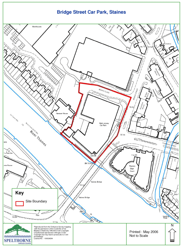
Allocation A9: Bridge Street Car Park, Staines (P/004/H & P/004/C) |
|
|
|
Site Description |
6.68 |
Bridge Street is a single deck car park occupying a prominent position adjoining the River Thames next to Staines Bridge. The site has an area of 0.71ha and is a key “gateway” site at the entrance to the town from the south side of the River Thames. |
|
|
|
Allocation |
6.69 |
Residential development of approximately 75 dwellings is proposed including retention of an element of public car parking beneath. |
|
|
|
Timescale of development: 2009-2014 |
6.70 |
The site is owned by the Council and is available for redevelopment. |
|
|
|
Justification for allocation |
6.71 |
Redevelopment would provide an opportunity to create a high quality development that makes the most of this visually important site, offering the potential to enhance both the town centre and the setting of the river. |
6.72 |
Housing is considered the most appropriate use for the site in view of the need for housing, reflected in Core Strategy priorities, and other housing development along the river frontage. |
|
|
|
Development Criteria |
6.73 |
A high quality design will be needed that reflects the site’s gateway location within the Staines Conservation Area adjoining Staines Bridge and the River Thames. Care will be needed to achieve a satisfactory visual relationship with adjoining properties. |
6.74 |
An initial draft Planning Brief giving further guidance on requirements for the development of the site has been subject to consultation as part of the preparation of a Supplementary Planning Document (SPD) on the site. |
6.75 |
The bulk of the site lies within Flood Zone 2 and adjoins an area of Flood Zone 3a and functional flood plain (Flood Zone 3b). A flood risk assessment has been carried out which indicates that housing with parking beneath is acceptable in flood risk terms. However, any development proposal will require a detailed Flood Risk Assessment. |
6.76 |
Any development proposal would also require an assessment in conjunction with Thames Water to determine the need for local improvements to the sewerage network. Any improvements identified should be implemented prior to the occupation of the site. |
|
|
|
Relevant Policies |
6.77 |
The allocation supports implementation of Strategic Policy SP2 and Policy HO1(a) in the Core Strategy and Policies DPD. |
6.78 |
Planning applications for the allocated use will need to take particular account, amongst other policies, of relevant policies listed in paragraph 3.3 of this document. |
|
 |
|
|
|
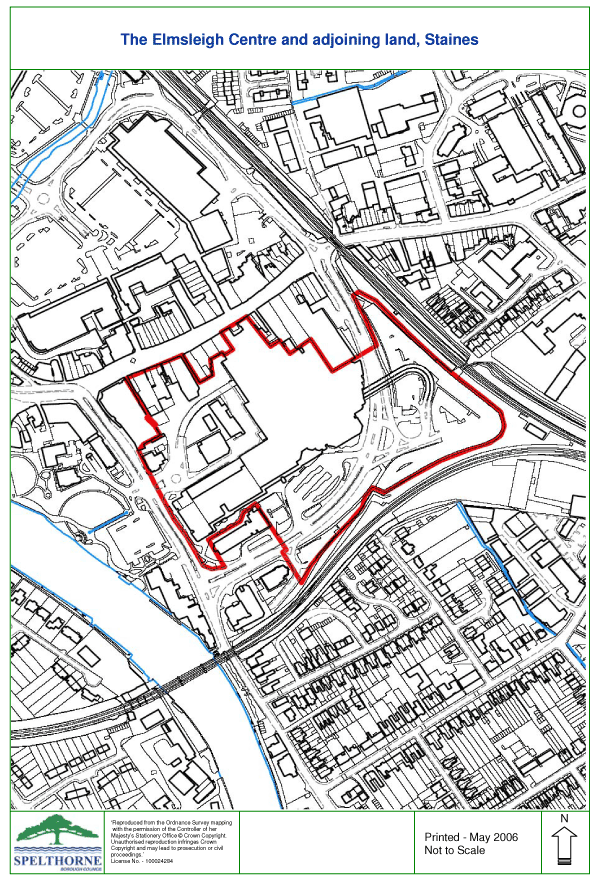
Allocation A10: The Elmsleigh Centre and adjoining land, Staines (P/030/M) |
|
|
|
Site Description |
6.79 |
Development will take place at the western and southern parts of this overall site of 6.62ha. |
|
|
|
Timescale of development |
6.80 |
2009-2014 (Phase 3) and 2019-2024 (Phase 4) |
|
|
|
Allocation |
6.81 |
It is proposed that the development would take place in two phases. |
6.82 |
Phase 3 - Redevelopment within the Elmsleigh Centre and extension to the south to provide approximately 2,500 sq m of retail floorspace, at least 30 flats and improvements to the bus station. This phase represents the last of three phases in a programme of refurbishment and redevelopment to enhance the existing Elmsleigh Centre. |
6.83 |
Phase 4 - Extension of the Elmsleigh Centre to the west to provide a comprehensive development including at least 18,000 sq m of retail floorspace, a mix of related non retail uses, approximately 65 flats, additional parking and revised access and servicing arrangements. This phase will enable the Elmsleigh Centre to grow to meet the retail needs of the Staines catchment area. It will create a better balance between shopping on the north and south side of the High Street and provide the opportunity for links with Debenhams and the western end of the High Street. It also makes better use of an under-used and unattractive site immediately adjoining the main part of the shopping centre. |
|
|
|
Justification for allocation |
6.84 |
The 2004 Spelthorne Retail Study and the 2007 update shows there is scope for further retail development in Staines to meet forecast growth in retail expenditure on non food items. The scale of the Allocation is consistent with the findings of the 2007 study update, which shows there is scope for a development of approximately 18,000 sq m up to 2016 and up to a further 32,000 sq m by 2026, subject to future monitoring. In the context of growing retail expenditure and consequent demand for extra floorspace a development of the scale proposed enables Staines to maintain its role as the principal town centre for north Surrey in accordance with Strategic Policy SP4. |
6.85 |
The inclusion of housing widens the mix of town centre uses and contributes to meeting housing needs. |
|
|
|
Development Criteria |
6.86 |
A traffic impact assessment will be required to demonstrate the acceptability of the proposals. |
|
 |
|
|
6.87 |
Development should include re-provision of the community centre, library and museum as part of any proposal which includes demolition of these existing facilities to provide a better comprehensive development of the area. |
6.88 |
The bulk of the site is within Flood Zone 3a. A flood risk assessment has been carried out by consultants Black and Veatch which demonstrates that, in principle, a development could be acceptable in flooding terms. However, any development proposal will require a detailed Flood Risk Assessment. |
6.89 |
Thames Water has confirmed that subject to the sewage flow being spread to a number of surrounding sewers, including ones crossing the site, there need not be a sewer capacity issue. However, a detailed scheme and sewer connections will need to be discussed with Thames Water. There is no known major network capacity issue in the vicinity of the site but one of the nearby pumping stations is close to capacity. |
6.90 |
An initial draft Planning Brief giving further guidance on requirements for the development of the site has been published and consulted on. The Council intends to progress the planning brief as a Supplementary Planning Document following adoption of this Allocations DPD. |
6.91 |
Any scheme will need to have regard to Policy CC4 of the Core Strategy and Policies DPD which requires the route of Airtrack to be safeguarded. |
|
|
|
Relevant Policies |
6.92 |
The allocation supports implementation of Strategic Policy SP4 on town centres and retail development and Policy TC1 which identifies the scope and role of extensions to the Elmsleigh Centre in providing additional retail floorspace. The allocation also supports Strategic Policy SP2 and detailed policy HO1(a). |
6.93 |
Planning applications for the allocated use will need to take particular account, amongst other policies, of relevant policies listed in paragraph 3.3 of this document. |
|
|
|
Other Developments |
|
|
|
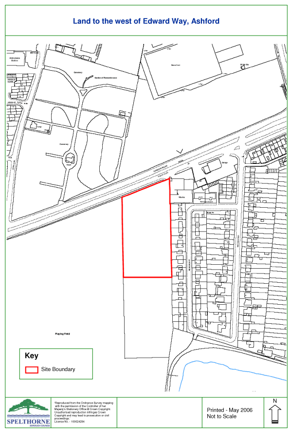
Allocation A11: Land to the West of Edward Way, Ashford (P/019/O) |
|
|
|
Site Description |
6.94 |
This site of 1ha is in the Green Belt and fronts the A30 with residential development along the eastern boundary. |
|
|
|
Allocation |
6.95 |
Public open space with possible children’s play area. The scheme will provide open space for residential areas within north Ashford with inadequate provision at present. |
|
|
|
Timescale of development: 2009-14 |
6.96 |
Implementation will be by the Council. |
|
|
|
Justification for allocation |
6.97 |
The Council’s Assessment of Open Space, Sport and Recreation Provision in Spelthorne identifies the area of northern Ashford immediately south of the A30 as an area lacking in open space provision. There is open land in this area that offers potential for open space use and this Allocation would overcome the local deficiency. |
|
|
|
Development Criteria |
6.98 |
It is proposed that only pedestrian access would be provided for users of the site given that it is intended to meet a local need only. Access for maintenance vehicles will be required. |
6.99 |
There is a need not to increase vehicular movements directly onto the A30 trunk road. |
6.100 |
The design of the scheme should safeguard the amenities of adjoining properties in Edward Way and access should be from London Road. |
|
|
|
Relevant Policies |
6.101 |
The allocation supports implementation of Strategic Policy SP5 on meeting community needs, Policy CO1(a) in the provision of new community facilities and Policy EN4 in the provision of open space. |
6.102 |
Implementation of the allocated use will need to take particular account, amongst other policies, of relevant policies listed in paragraph 3.3 of this document. |
|
 |
 |
|
|
|
|
| |
|
|