 |
| Back to Contents |
| |
4 |
Core Strategy and Policies |
| |
|
| |
Introduction |
4.1 |
This chapter sets out the spatial strategy of the DPD which has been developed from the spatial description of the Borough (Chapter 2) and the vision and objectives (Chapter 3). It also explains the role of the strategic and detailed policies of the DPD in delivering the spatial strategy. |
| |
|
| |
Spatial Strategy |
4.2 |
The spatial strategy will meet future development requirements from within the existing urban area which lies broadly across the middle of the Borough and largely constitutes a continuous built up area. |
4.3 |
Housing provision will meet the requirements of the draft Regional Spatial Strategy for the South East. It will be in areas free of unacceptable flood risk with consequently a relatively greater proportion of the total additional housing provision, in comparison to the proportion of the Borough’s existing stock, in Ashford (38%) and Stanwell (14%) and relatively less or the same in Staines (25%), Shepperton (11%) and Sunbury (13%). Over the plan period, whilst the population is expected to fall, decreasing household sizes require more dwellings and smaller ones. Provision will be mainly for small dwellings (80% one and two bedroom) to meet the growth in smaller households. This will include provision for a growing elderly population. At least 40% of all new housing will be affordable. |
4.4 |
The Borough has a buoyant housing market and delivery will be largely market driven. Interventions by the Council and other agencies will involve promoting development through Allocations DPDs, planning briefs, providing advice and encouragement, review of the Strategic Housing Land Availability Assessment (SHLAA) to identify further larger sites if required, and the use of planning powers, e.g. CPOs. There is likely to be a greater proportion of housing in the first half of the plan period because of existing commitments, but this will assist in meeting outstanding affordable housing need in particular. |
4.5 |
The requirement for at least 40% of new housing to be affordable requires provision to be made from all schemes of 15 or more dwellings. |
4.6 |
4.6 Employment capacity will be maintained. Major existing employment areas will be protected and include the town and local centres of Staines, Ashford, Shepperton and Sunbury Cross and the designated Employment Areas at Windmill Road Sunbury, Hanworth Road/Country Way Sunbury, BP Chertsey Road Sunbury, Ashford Road/Littleton Road/Spelthorne Lane Ashford, London Road east of the Crooked Billet Staines, Bedfont Road/Long Lane Stanwell and Shepperton Studios. Employment growth will occur in Staines, where there is particular scope for growth and this use is less constrained by flood policy, and through implementation of existing commitments, including those at Heathrow T5 just outside the Borough and Shepperton Studios. This growth will more than compensate for the loss of poorly sited employment land to be used for housing, of which a greater proportion is in the Ashford area. |
4.7 |
Employment capacity will be maintained. Major existing employment areas will be protected and include the town and local centres of Staines, Ashford, Shepperton and Sunbury Cross and the designated Employment Areas at Windmill Road Sunbury, Hanworth Road/Country Way Sunbury, BP Chertsey Road Sunbury, Ashford Road/Littleton Road/Spelthorne Lane Ashford, London Road east of the Crooked Billet Staines, Bedfont Road/Long Lane Stanwell and Shepperton Studios. Employment growth will occur in Staines, where there is particular scope for growth and this use is less constrained by flood policy, and through implementation of existing commitments, including those at Heathrow T5 just outside the Borough and Shepperton Studios. This growth will more than compensate for the loss of poorly sited employment land to be used for housing, of which a greater proportion is in the Ashford area. 4.7 Growth in retail floorspace needs of approximately 32,000m2 will be met in Staines with the role of the other three main centres of Ashford, Shepperton and Sunbury, and other existing local centres and parades, maintained to meet local needs. The expansion of Staines’ retail function will be achieved by two extensions to the Elmsleigh Centre, broadly in the first half of the plan period, and the scope in the longer term to meet retail growth by intensifying retail development on the Two Rivers site. The Elmsleigh Centre extension will be progressed by proposals in the Allocations DPD and preparation of a Planning Brief as an SPD. The Council will be working in partnership with the respective landowners and leaseholders. |
4.8 |
A comprehensive approach to flood risk defines where new development can go in order to avoid unacceptable risk. This includes measures to seek to contribute to reducing the degree of flooding in the Borough through specific flood mitigation measures and betterment through development that can otherwise appropriately take place in areas of flood risk. Restrictions on development will apply particularly to the west and southern parts of the Borough covered by Staines, Shepperton and the southern part of Lower Sunbury. |
4.9 |
There are some areas which are short of public open space, particularly in Ashford, which will be addressed, but otherwise there are no significant gaps in existing provision for community needs requiring resolution through this DPD. Any arising from new development will be expected to be provided or contributed to. |
4.10 |
The environment is of particular importance to local people and will be maintained and improved by ensuring new development is well designed and attractive and makes a positive contribution to the locality in which it is situated. Both the historic environment and areas of landscape value and nature conservation value will be protected and enhanced. A range of actions is necessary to redress the impact of climate change and poor air quality and the contribution of traffic in Spelthorne to its adverse affects. |
4.11 |
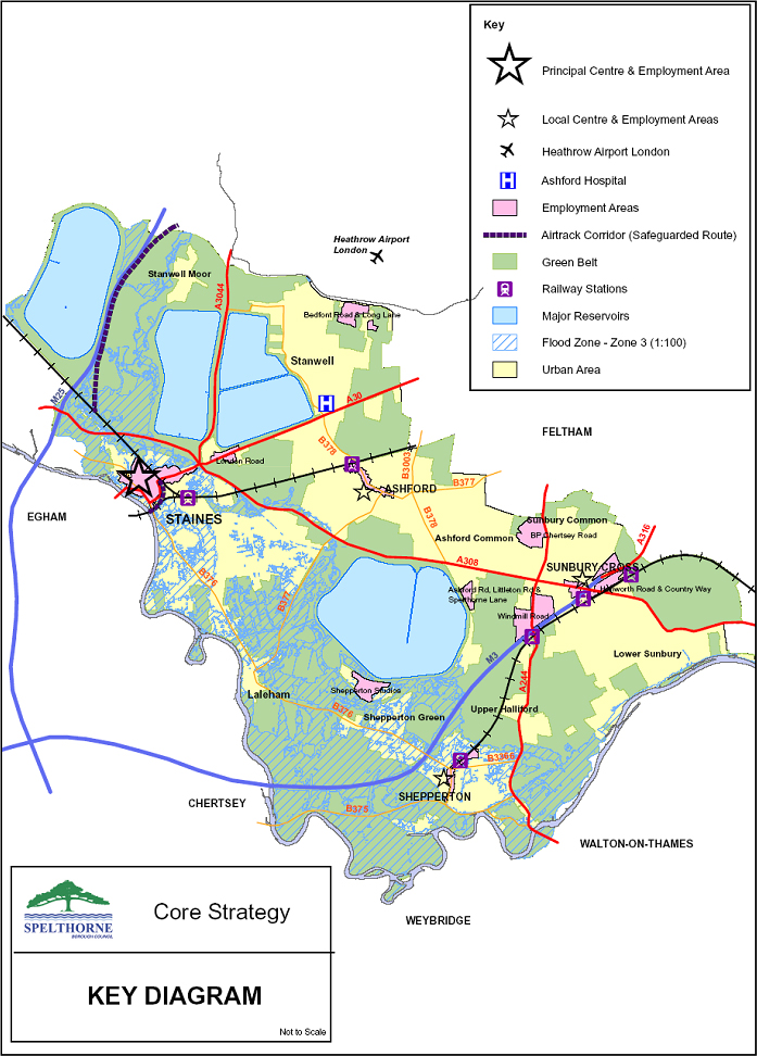
Table 1 explains how the development requirements of the spatial strategy apply to the five main areas of the Borough. The major locational issues in the Borough are shown in the Key Diagram at the end of this chapter. |
4.12 |
The spatial strategy is delivered through seven strategic policies and 37 detailed policies. These are set out in Chapters 5-11. |
|
|
| |
Table 1 - Development Requirements arising from the Spatial Strategy |
| |
|
Housing (1) |
Employment |
Shopping |
Major place shaping issues |
Staines
|
Approx 25% of additional housing (820) including 4 Allocation sites - some in town centre with scope for higher densities - delivering approx 300 dwellings. |
Designation for employment:
- Commercial area of town centre (32.6ha)
- London Road east of Crooked Billet. (4.7ha)
Further employment by implementation of existing commitments and redevelopment. |
Provide an additional 32,000m2, initially in two phased extensions of the Elmsleigh Centre of a total 20,500m2, and in the longer term through additional space north of the High Street. |
Large area at flood risk. Proposals to enhance public transport interchange facilities including improvements to Bus Station. Airtrack route safeguarded. Contribution of River Thames to character of area. |
Ashford
|
Approx 37% of additional housing (1250) including 4 Allocation sites on poorly sited employment land providing approx 189 dwellings. |
Designation for employment:
- Town centre (7.7ha)
- Spelthorne Lane/Littleton Road. (4.7ha)
|
Maintain the role of the existing shopping centre and local parades to meet local needs. |
Some areas short of open space – Allocation site adj. Edward Way and requirement for open space within two larger housing Allocation sites. Area is largely free of flood risk. |
Stanwell including Stanwell Moor
|
Approx 14% of additional housing (450) Two large sites at Holywell Way and Ashford Hospital will deliver approx 250 dwellings. |
Designation for employment:
- Northumberland Close and Long Lane (10.9ha)
|
Maintain the role of the existing shopping centre at Clare Road in Stanwell and local parades to meet local needs. |
Aircraft noise and public safety zone over part of Stanwell Moor. Closest to Heathrow. Stanwell is largely free of flood risk. |
Shepperton including Charlton
and Upper Halliford |
Approx 11% of additional housing (370) including an Allocation site of approx 85 dwellings. |
Designation for employment:
- Shepperton centre including commercial area in Govett Avenue. (7.4ha)
- Shepperton Studios (11.1ha)
|
Maintain the role of the existing shopping centre and local parades to meet local needs. |
Large area of flood risk. Contribution of River Thames to character of area. |
Sunbury |
Approx 13% of additional housing (430) with an Allocation site of approx 50 dwellings. |
Designation for employment:
- Sunbury Cross (5.3ha)
- Windmill Road (22.3ha)
- Hanworth Road (11.9ha)
- BP at Chertsey Road (14.3ha)
|
Maintain the role of the existing shopping centre at Sunbury Cross, Lower Sunbury and local parades to meet local needs. |
Areas of flood risk in southern part of lower Sunbury. Contribution of River Thames to character of area. |
|
| |
| |
|
| |
Core Strategic Policies |
4.13 |
The seven strategic policies cover the following issues |
| |
- general location of development,
- housing provision,
- economy and employment provision,
- town centres and retail development,
- community needs,
- maintaining and improving the environment,
- climate change and transport.
|
4.14 |
The remainder of this DPD has seven sections dealing with each strategic policy (referenced by the letters SP) with the relevant detailed policies set out after them. For each section there is a brief summary of the relevant part of the spatial strategy with a link to the relevant plan objectives. While only the most relevant objectives are listed the policy may also contribute to achieving other objectives. |
| |
|
| |
Structure of the DPD |
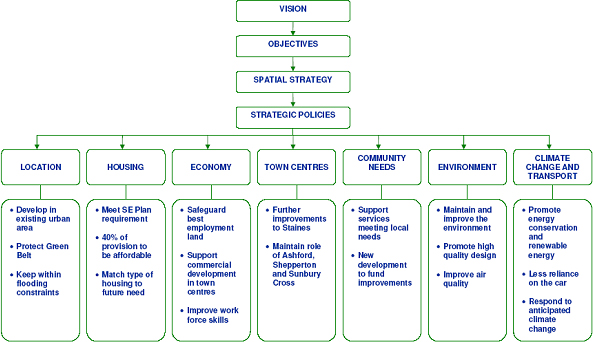
4.15 |
The relationship of the vision, objectives, spatial strategy, strategic policies and general scope of the detailed policies is summarised in Figure 1. |
|
|
| |
Figure 1 - The Core Strategy and Policies in Summary |
|
| |
|
| |
Detailed Policies |
4.16 |
The detailed policies in each section provide more detail on how the relevant strategic policy is to be delivered. This DPD as a whole is a spatial plan in both a geographic sense, in applying to specific areas, and in its reliance on a wide range of implementation actions, including the plans and programmes of both the Council and other organisations. The policies do not, therefore, solely rely on planning applications and operation of the development control process as a means of implementation. |
4.17 |
Some policies are therefore quite wide ranging in their approach to specific issues. Some detailed policies will inevitably be more ‘cross cutting’ in that they may be relevant to more than one single strategic policy. For example flooding has a locational dimension as well as being relevant to climate change and building design. |
4.18 |
It is important that the policies are applied as a whole and the general absence of detailed cross referencing should not be taken to imply otherwise. |
 |
|
 |
|
|
|
|
| |
|
|