 |
| Back to Contents |
| |
2 |
Spatial Description of Spelthorne |
2.1 |
This chapter describes the main characteristics of the Borough and then identifies the key issues which it faces and need to be addressed in this Development Plan Document (DPD). |
2.2 |
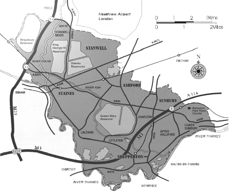
Spelthorne lies approximately 15 miles south west of Central London. It is a relatively small Borough which is some six miles long and two and a half miles wide with an area of 5,116 hectares. It is relatively densely populated with a population of approximately 92,135 in 2006. It is bounded by Heathrow Airport to the north, the River Thames to the south and London Boroughs to the east, while the M25 runs close to its western boundary. Its main urban areas are Ashford, Shepperton, Staines, Stanwell and Sunbury (see Map 1). |
| |
|
| |
Map 1 - Borough of Spelthorne |
| |
 |
| |
| |
2.3 |
Spelthorne is located where the continuous built up area of London gives way to a more dispersed pattern of urban areas and villages. The urban area of the Borough occupies about 35% of the total area. The larger part of the urban area of Spelthorne lies across the middle of the Borough from east to west. Stanwell, Ashford and Sunbury comprise a continuous urban area with no separation by open land and there is only a small gap between Staines and Ashford. The settlements of Stanwell Moor, Laleham, Shepperton, Upper Halliford and Charlton are separate urban areas albeit by only small distances. There is a clear belt of open land separating the urban areas of Spelthorne from outer London. |
2.4 |
Land outside the urban area covers about 65% of the Borough and is designated as Green Belt. It is part of the Metropolitan Green Belt surrounding London and has an important strategic role in containing the outward spread of the capital and providing a belt of open land for air and exercise. Locally the Green Belt serves not only to contribute to the wider strategic function but also separates existing settlements within the Green Belt maintaining their distinct physical identity and character. Within the Green Belt in Spelthorne are five major water supply reservoirs and a water treatment works at Ashford Common. Some areas of the Green Belt need environmental improvement. |
2.5 |
Spelthorne adjoins the River Thames and is crossed by two tributaries, the Ash and the Colne. The Borough is flat and low lying and consequently liable to flood. About 7% of the urban area is liable to flood in a 1:100 year flood event or be surrounded by flood water and over 35% of the urban area would be flooded in a 1:1000 year event. Flood risk is a very serious threat with some 2,800 homes within the 1:100 flood risk area (Zone 3). The flood risk area affects the south and west side of the Borough, including large parts of Staines and Shepperton and limits the scope for further development. The Environment Agency is currently developing proposals to reduce flood risk in Spelthorne and adjoining Boroughs. |
2.6 |
The general extent of the Green Belt and the Zone 3 flood risk area are shown on the Key Diagram and Proposals Map. |
2.7 |
The whole of the Borough is designated as an Air Quality Management Area because of poor air quality. The primary pollutants are nitrogen dioxide (NO2) and particulates (PM10). Both result from traffic. There are particular concentrations of pollution from NO2 in parts of Staines and around the Sunbury Cross junction and other parts of the A308. The level of particulates is a concern adjoining the M25 and Heathrow Airport. The Council’s Air Quality Management Action Plan, Community Plan and the County Council’s Local Transport Plan already have policies and actions to encourage non-car use to help combat the air pollution problem. |
2.8 |
In the north of the Borough there are areas suffering high levels of noise from Heathrow Airport, in particular at Stanwell Moor and the northern part of Stanwell. Housing development in the most affected areas is restricted to one for one replacement only. The northern part of Stanwell Moor is also affected by part of the public safety zone for the west end of the southern runway. |
2.9 |
Spelthorne has about 39,500 dwellings and a relatively high level of owner occupation with a social housing stock of only 11.8%. It has a higher proportion of semi-detached and terraced properties and flats than the rest of Surrey. The mix of dwellings results in a higher prevailing density of housing than found in the rest of Surrey and more akin to that found in adjoining London Boroughs. Housing sites that come forward generally tend to be small and are all by way of redevelopment, infill or conversion in the urban area. House prices in Spelthorne are relatively high. There are in excess of 3,000 people on the Spelthorne Housing Register and there exists an on-going need for affordable housing. |
2.10 |
Spelthorne’s population is slightly older and its average household size slightly smaller than the national average. It has a relatively small ethnic minority population (5.7%), of which the largest group is Indian (2%). There are in general no particular needs arising from this group which do not arise from the population as a whole. Over the next 20 years the total population is projected to fall slightly and its composition will alter. The 0-14 age group will continue to fall as will the 24-44 age group. All age groups over 50 will rise with a particularly significant percentage increase in the 85+ age group. Average household sizes will continue to fall requiring further housing. Almost 30% of households in Spelthorne are single person households yet 63% of the housing stock is three bedrooms or larger. The North Surrey Extra Care Housing Strategy 2005 identifies a need for 200 units of extra care accommodation in Spelthorne by 2016. Projecting this forward to 2026 would require 400 in total. Future provision will need to meet the growth in small households, including supported accommodation suitable for the elderly. |
2.11 |
A relatively high proportion of the population is ‘economically active’ (either in work or seeking work). The unemployment rate is 1.8% (January 2009). This is above the Surrey average of 1.5% but below the South East average of 2.4%. It is also below the national average and the figures for other authorities adjoining Heathrow (Hillingdon, Hounslow and Slough). Job vacancies exceed unemployment levels. The Borough’s workforce has more middle ranking intermediate and supervisory roles compared to the national average and less in both professional/managerial and unskilled workers. This is reflected in the educational qualifications of the workforce which show lower levels of educational attainment. |
2.12 |
There is a substantial flow of commuting both into and out of the Borough, with a net outflow of about 8,000 workers. Most of the outflow is to major centres of employment just outside the Borough, including Heathrow Airport, which alone employs over 4,800 Spelthorne residents (10% of the workforce) (BAA Heathrow employment survey, 2004), Bedfont Lakes in Hounslow and the Poyle Trading Estate in Slough. |
2.13 |
Spelthorne is an attractive location for business due to the proximity of Central London, Heathrow and the motorway network. Its own economy includes a significant legacy of industrial estates scattered throughout the Borough. The decline of manufacturing has seen some of these change to residential, while, in more accessible locations, redevelopment has taken place for offices or high tech industry. In comparison with other Surrey districts Spelthorne still has a relatively large amount of industrial floorspace. The Borough is also a significant centre for warehouse floorspace, particularly for airport-related warehousing close to Heathrow. Heathrow has a major economic impact on the area around it including Spelthorne. It employs around 75,000 people on-site and has extensive secondary employment in support services including hotels. Office employment has grown, particularly in Staines town centre, although floorspace in the Borough as a whole is still below the average for Surrey districts. There is a significant stock of permitted employment floorspace notably at Terminal 5, Shepperton Studios and in Staines town centre and there is no need to provide additional employment land to meet the Borough’s needs. |
2.14 |
The Spelthorne Retail Study 2004 and the 2007 update showed there is scope for further significant growth in shopping provision in the period to 2026 in Staines, particularly in non food retailing. Staines is seen as the best location in both market demand and in accessibility terms. There is physical scope for further major expansion adjoining the Elmsleigh Centre. Without growth Staines is likely to lose an increasing proportion of retail expenditure to centres outside the Borough. |
2.15 |
The retail studies showed that Ashford, Shepperton and Sunbury Cross were well-used by their local communities. There is no scope for significant expansion but opportunities for improvement need to maintain their role. Local parades provide convenient shopping facilities for local communities and are important. |
2.16 |
There are some relatively small areas of deprivation in parts of Stanwell, Staines, Ashford and Sunbury Common based on the Index of Multiple Deprivation (IMD). This compares data on a number of issues including income, employment, education, skills and crime and disorder to create a relative score. Income, education and employment are inextricably linked. Training and crime and disorder are issues which have received particular attention in the Spelthorne Community Plan. In general the living environment and access to housing is good in these areas. |
2.17 |
Whilst the draft Regional Spatial Strategy for the South East (July 2008) housing requirement for Spelthorne over the period from 2006 to 2026 is 3320 dwellings, as described earlier, projections show that the population as a whole will be little changed and the need for additional services and infrastructure will be limited. Service providers have been asked about future requirements. There are no additional infrastructure needs in terms of water, gas, electricity and sewage disposal. Certain developments may require very localised improvements to the sewer network. Council services for the elderly have already been reviewed and the projected growth in the number of elderly taken into account. |
2.18 |
There is overall good provision for open space, sport and recreation in the Borough as a whole although there are areas of more limited provision in parts of Ashford and Staines and steps are required to improve this. A study of open space, sport and recreation in 2005, and a separate study of allotments in the same year, has shown there are no sites surplus to requirements. |
2.19 |
Hospital services are split between Ashford and St. Peters, Chertsey and provision is determined by the Hospital Trust, which has no need for additional land for provision in the Borough. There are five health centres, of which four need improving. The need for improvements is not related to new development but the condition and lack of flexibility of the existing buildings. Plans are already being developed for Stanwell and Shepperton and in-situ solutions are currently contemplated for Staines and Sunbury. |
2.20 |
With a falling 0-14 population no additional school capacity is required. There is a need to improve the education of 16-19 year olds and reorganisation of provision is underway with Spelthorne College (Ashford) and Brooklands College (Weybridge) having recently combined. Redevelopment of the Ashford site to improve capacity and facilities is currently under consideration. |
2.21 |
Spelthorne contains areas of national and international significance for nature conservation. Most of its major reservoirs form part of the South West London Waterbodies Special Protection Area, in recognition of their international significance as a habitat for two particular species of wildfowl. Additionally the Staines Commons form a substantial Site of Special Scientific Interest (SSSI), which means they are of national importance for nature conservation as well as an important historic landscape. There are also smaller SSSIs and other areas of local nature conservation importance in the Borough. |
2.22 |
Spelthorne sits on river gravels, which are an important mineral resource. The open areas of the Borough contain a mixture of past workings that have been restored to varying standards including some schemes that have created new habitats and landscapes. Most mineral extraction sites are filled with inert material. Minerals and Waste disposal planning is the responsibility of the County Council and subject to a separate Local Development Framework. |
2.23 |
Recreation is a significant land use in the Borough, including formal sporting sites such as Kempton Park racecourse, sailing on reservoirs and lakes, three golf courses and various parks and sports grounds as well as informal recreation including common land. The River Thames and its towpath define about 50% of the Borough boundary and attracts people from a wider area as well as being an important environmental amenity. |
2.24 |
The following sections describe different parts of the Borough. |
2.25 |
Staines is Spelthorne’s major shopping centre with a catchment area covering the whole Borough and adjoining areas to the west and south. It is also the main commercial centre in the Borough. It has seen major development in recent years, including the Two Rivers shopping centre and refurbishment of the Elmsleigh Centre, which has greatly improved the range and quality of shopping available. The town centre has also seen major environmental improvements including High Street pedestrianisation and improvements to the riverside. The main residential areas of Staines are to the east and south of the town centre. |
2.26 |
Staines has problems of traffic congestion and some related air quality issues and it is important that further development does not add to this. Significant parts of Staines town centre are liable to flood and the Strategic Flood Risk Assessment has evaluated the economic and social case for continued retail growth and the scope to mitigate any flood risk. There are a few significant sites which can make a contribution to future housing needs. |
2.27 |
A distinctive feature of the area north and east of Staines is the extensive areas of common land, notably Staines Moor and Shortwood Common. These are of historic as well as amenity and nature conservation value. |
2.28 |
Ashford lies in the centre of the Borough and forms its largest residential area. Its town centre, which primarily serves local needs, is linear in character and is surrounded by adjoining residential areas. Ashford has a number of commercial areas some close to housing and accessed through residential areas; the largest is at Littleton Road and contains a mix of industrial and office floorspace. Ashford Hospital is also a major employer. Ashford has a shortage of open space in some locations. |
2.29 |
Stanwell extends from Ashford to the boundary with Heathrow. While it has an historic village centre in the north, Stanwell was mostly developed to the south, as far as the A30, in the immediate post war years with a high proportion of social housing. Much of that housing has now been sold to former tenants. In comparison with the rest of Spelthorne, parts of Stanwell suffer from relatively high levels of social deprivation. Heathrow has a substantial impact on the northern part of Stanwell due to noise disturbance and the impact of airport related development, although stretches of open land between parts of Stanwell and the airport help to maintain a separate identity for the community. |
2.30 |
Stanwell Moor is a separate village to the west of Stanwell. It is surrounded by open land and maintains a distinct identity. It lies partly under the flight path from the airport’s southern runway and is severely affected by aircraft noise. |
2.31 |
Sunbury lies at the eastern end of the Borough. It is split in two by the M3. Junction 1 of the motorway is at Sunbury Cross, which was developed in the 1970s to include several high rise commercial and residential buildings and a shopping centre. A large Tesco superstore was constructed nearby in the early 1990s. The Sunbury Common area north of the M3 includes the Borough’s largest industrial estate at Windmill Road and another significant commercial area at Hanworth Road, both of which contain a mixture of traditional and modern premises. It also contains a major BP office and research facility. Lower Sunbury is a large residential area to the south of the M3. Parts of Sunbury have relatively higher levels of deprivation compared to the rest of the Borough. There is a particular concentration of poorer air quality around the Sunbury Cross junction. |
2.32 |
Shepperton is a distinct settlement in the southern part of the Borough. It is primarily residential with a significant local shopping centre and a business park. Its major commercial site is Shepperton Studios, which lies in the north western part of the built up area. |
2.33 |
Other smaller communities include Charlton, Laleham and Upper and Lower Halliford. |
| |
|
| |
Summary of Issues |
2.34 |
Many of the issues faced by the Borough are also common to authorities in the wider area, such as high house prices, strong economy, traffic congestion, a strong desire to protect and enhance the environment and maintaining the role of town and local centres. There are also issues facing all authorities including matters relating to climate change. |
2.35 |
There are however, in addition, particular issues facing Spelthorne. These are: |
| |
meeting future development requirements within a limited urban area which is constrained by significant flood risks, |
| |
reducing the extent of flood risk, |
| |
improving air quality, |
| |
meeting the particular need for affordable housing, |
| |
noise from Heathrow. |
2.36 |
In addition to these major local issues there are other matters of local significance and include, housing for a growing elderly population, growth in need for smaller dwellings, supporting initiatives to increase the skills of the work force, risks within the public safety zone, the environmental and visitor issues relating to the River Thames and balancing the demands for housing with other uses of land. |
2.37 |
These issues, particularly those identified in paragraph 2.35, are dealt with in this DPD. |
2.38 |
Some issues apply to the Borough as a whole such as affordable housing and others to particular areas e.g. flooding, air quality, focussing development on urban areas and the role of existing centres. These issues are reflected in the vision, objectives and policies of this document. |
 |
|
|
|
|
| |
|
|